| AIRPHOTO INTERPRETATION CLASSICS www |
R. A. KREIG & ASSOCIATES |
 |
| AIRPHOTO INTERPRETATION CLASSICS www |
R. A. KREIG & ASSOCIATES |
|
List of hard to find early key publications in the development of the "Belcher-Cornell school" of civilian airphoto interpretation methodologies. Compiled by Ray Kreig.
Belcher, Donald J., 1943, The engineering significance of soil patterns. Proc. Twenty-third Annual Meeting of the Highway Research Board, November 1943: 560-598. NOTE: Belcher received the 1944 Highway Research Board Award for this paper. The HRB only gave out one of these per year.
Belcher, D.J., Gregg, L.E., and Woods, K.B., 1943, The formation, distribution, and engineering characteristics of soils; a report of an investigation conducted by the Engineering Experiment Station, Purdue University, in co-operation with the State Highway Commission of Indiana: [Purdue University, Lafayette, Ind. Engineering Experiment Station] Highway research bulletin no. 10; Research series no. 87: Lafayette, Purdue University, 389 p. Cover Table of contents Soil profile examples Data table II
Belcher, Donald J., 1946, Engineering Applications of Aerial Reconnaissance. Bulletin of the Geological Society of America 57:727-734.
Jenkins, D.S., Belcher, D.J., Gregg, L.E., and Woods., K.B., 1946, The origin, distribution, and airphoto identification of United States soils. With special reference to airport and highway engineering: Washington, U.S. Dept. of Commerce Civil Aeronautics Administration, 2 v. Folded map and charts in pocket. Vol. 1: Text, Appendix A, p. 138+; Vol. 2 [labeled "Appendix B"]: Airphotos. These two volumes are the subject of considerable confusion in cataloging because the second volume does not display the authors names and neither volume indicates that it is "Volume 1 or 2"; in fact the second volume says it is "Appendix B". The two volumes are frequently cited and catalogued as separate items:
[Volume 1]
Jenkins, D.S., Belcher, D.J., Gregg, L.E., and Woods, K.B., 1946, The origin, distribution, and airphoto identification of United States soils. With special reference to airport and highway engineering: Washington, U.S. Dept. of Commerce, Civil Aeronautics Administration, Technical Development Report 52, 4 plates, [8], 202 p. One map and three diagrams folded in pocket (further described below). Bibliography: p. 167-202. Cover Table of contents
Contains this map in the pocket:
Belcher, D.J., Gregg, L.E., Woods, K.B., and Jenkins, D.S., 1946, Origin and distribution of United States soils: Washington, U.S. Dept. of Commerce. Civil Aeronautics Administration. 30" x 50" color map; Scale 1:4,000,000. Map shows the genetic (landform) basis of soils of the United States. Ray Kreig has a detailed 220 MB scan file of the whole map. This map was separately reprinted by coauthor Prof. D.J. Belcher at the Center for Aerial Photographic Studies, Cornell University School of Civil Engineering and used in classes at least once prior to 1970.Pocket also includes three 18" x 29" diagrams:
Air-Photo Analysis Charts
- Part One - Residual Soils
- Part Two - Aeolian Soils, Glacial Soils
- Part Three - Alluvial and Waterlaid Soils[Volume 2]
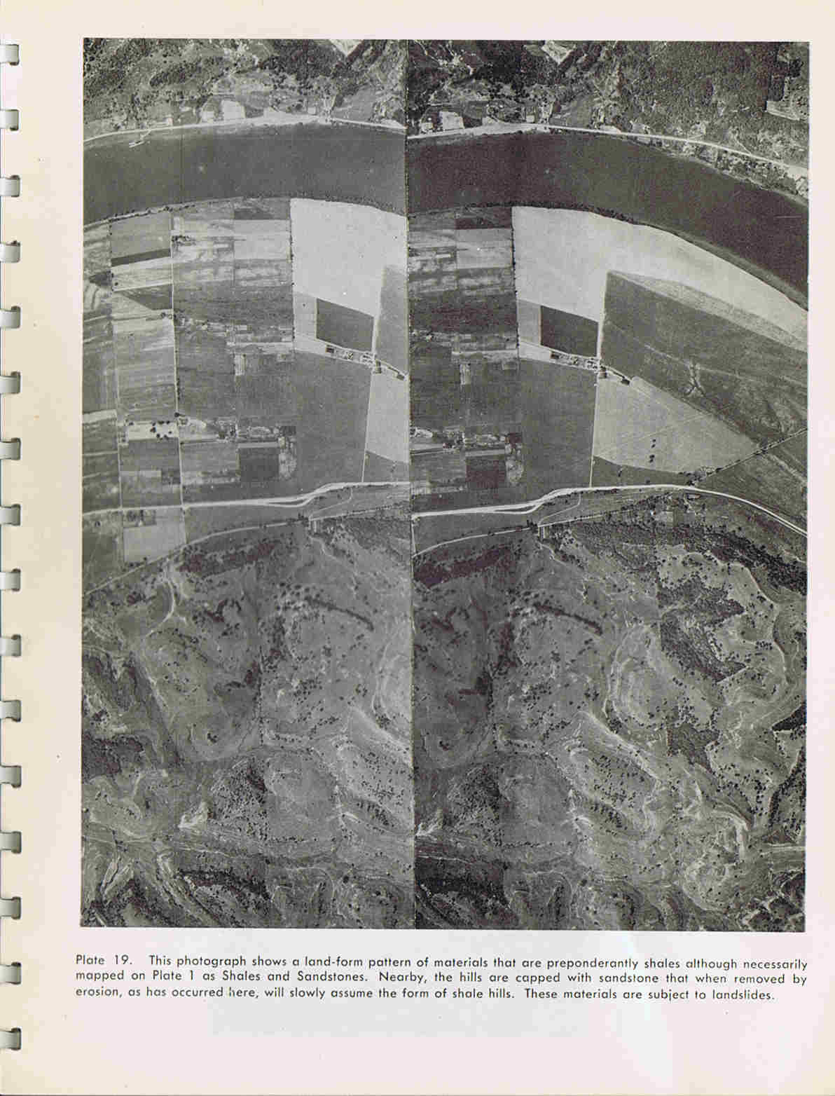
Jenkins, D.S., Belcher, D.J., Gregg, L.E., Woods, K.B., and U.S. Dept. of Commerce. Civil Aeronautics Administration, 1946, Airphotos illustrating the origin, distribution, and airphoto identification of United States soils : Appendix B of Preliminary Technical Development Report No. 52: Washington, U.S. Dept. of Commerce. Civil Aeronautics Administration, 62 plates + [2] p. ; 27 cm. Cover Table of contents Plate Example
Belcher, D. J., 1948, The engineering significance of landforms. Highway Research Board Bulletin 13:9-29.
Belcher, D. J., United States. Office of Naval Research Amphibious Branch., Naval Photographic Interpretation Center (U.S). and Cornell University. School of Civil Engineering, 1951, A Photo-analysis key for the determination of ground conditions : land form reports: Technical report ; no. 3: Ithaca, Cornell University, 6 v.
Gilman, W., 1955, Report on a new profession: PHOTOANALYST: Popular Mechanics (April 1955), p. 118-121, 240-248. text
Belcher, D.J., Liang, T., Cheney, T.A., Cornell University Airphoto Interpretation Team, Bushnell, T., Merritt, V., Edmondson, F., and Johnson, C., 1955, Airphoto analysis of landforms, Union of Burma: Ithaca, NY, Cornell University. School of Civil Engineering. Center for Aerial Photographic Studies., for US Foreign Operations Administration. Union of Burma., at least 178 p., 1 of 3 v., June 1955. [Vol 2 is Forestry, Vol 3 is Regional and urban planning]
Lueder, Donald R., 1959, Aerial photographic interpretation. New York, McGraw-Hill, 462 p.
Liang, T., 1964, Tropical soils: characteristics and airphoto interpretation: [Ithaca NY], Cornell University. School of Civil Engineering, for Air Force Cambridge Research Laboratories. Office of Aerospace Research. United States Air Force. Bedford, Massachusetts, FINAL REPORT AFCRL-64-937, xvii, 164, [20] p., August 31, 1964.